The Arkansas in the Civil War Message Board
Anyone have information about Reynolds Brigade and the Battle of Peachtree Creek GA (July 20, 1864)? The marker for Reynolds Arkansas Brigade stands on Howells Mill Road, about 750 feet NW of the marker for Maj William C Preston. Preston was killed while directing gunners of Selden's Alabama Battery.
As best I understand,
Norfleet Road NW runs along the ravine; McKinley Road NW runs parallel along the ridge held by Robinson's 3rd Brigade, 1st Division, 20th Army Corps. Knipe's 1st Brigade, 1st Division, held a line that ran NW along Howell's Mill Road. Alpheus Williams, the division commander, detached three regiments from his 2nd and 3rd Brigades to support the right of Knipe's Brigade.
The Federal defensive position appears to be a V, the right bar being concave and the left bar conforming to Howell's Mill Road. If so, Selden's Alabama battery position would be a short distance (100-150 feet) south of the base of the V. When Reynolds asked for support, the division artillery commander, Major William C Preston, brought up Selden's Battery and led it to this position. It was Major Preston's last act on earth, being killed a short time later. Underbrush and thickets would've shielded much of the Federal line from view, but it seems a wonder that everyone in this battery didn't meet a similar fate.
Did regiments from Reynolds Brigade attack Knipe's Brigade on the west AND Robinson's Brigade further east? Seems incredible for such a small command (Reynolds says 540 effectives) to have attacked two brigades supported by six pieces of artillery, each brigade having almost twice the numbers Reynolds could bring to bear. Also, Reynolds and his men represented the Confederate left flank. O'Neal's Brigade of Walthall's Division connected Reynolds on the right, but on the left French's Division remained some distance behind to the SW.
Am I missing something?
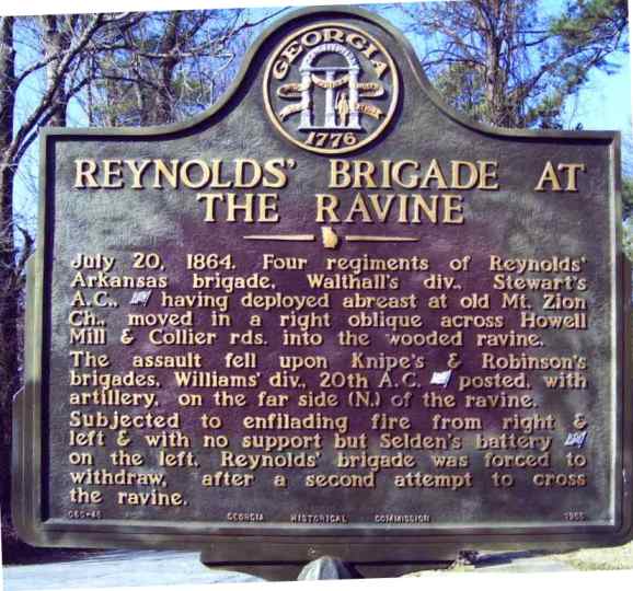
Reynolds Brigade at the Ravine
http://georgiainfo.galileo.usg.edu/gahistmarkers/reynoldsbrigadehistmarker2.htm
Major William C Preston
http://georgiainfo.galileo.usg.edu/gahistmarkers/majwmcprestonhistmarker.htm
Right of 20th Army Corps Line
http://georgiainfo.galileo.usg.edu/gahistmarkers/rtof20thaclinehistmarker.htm
Messages In This Thread
- Reynolds Arkansas Brigade - Peachtree Creek