
The demand for deerskins in Europe drastically reduced the amount of game on Cherokee hunting lands. Cherokees and other tribes traded heavily with the colonists to obtain firearms, knives, tools and other items of European manufacture. Hunting by traders and colonists contributed to the rapid reduction in game in the region. To maintain their hunting lifestyle and to escape the European influences on their culture, some Cherokees began to move to the west. Encroachment on Cherokee lands increased significantly after the Revolutionary War encouraging western movement in even greater numbers. The young United States wasted no time in beginning its strategy to move the Indian tribes to the west.
There is no doubt that the Cherokee were familiar with lands west of the Mississippi River and that hunting parties had ranged as far west as the Great Plains region. The first emigration may have occurred in about 1721. A traditional story of the so-called "lost Cherokee" reports that a faction of the tribe headed by Yunwi-usgaseti, "Dangerous-man", decided to move west to escape the influence and insatiable demands for land of the colonists. Upon crossing the Mississippi River, communication with this group ended until years later when stories began to spread that a Cherokee settlement had been discovered at the base of the Rocky Mountains living in the traditional Cherokee fashion. In the 1840's, a contingent of Cherokees which included Sequoyah travelled to Mexico and reportedly found this group.
In 1788, Cherokee who had been allied with the British contacted the Spanish governor in New Orleans and were granted permission to settle in Spanish territory west of the Mississippi. It is not known how many Cherokee moved west at this time but it is known that Cherokee and Shawnee were frequent visitors to Spanish settlements in this region.
In 1794, a group of Cherokees of the Chickamauga faction killed the six men of a party of whites travelling down the Tennessee River by flatboat from Knoxville to Natchez to settle in Spanish territory. The Cherokees, fearing reprisals from the main body of the tribe who was in the process of negotiating a peace treaty, travelled up the St Francis River into Spanish territory to await a response. Initially the tribal leaders condemned their actions but later exonerated them of any wrong doing. Angered by the initial response of the main body of the tribe and pleased with the land and availablity of game in the region, the group decided to remain in the area. (Chief Duwali has often been erroneously reported as leader of this group but he did not move west until 1810.)
The territory later know as the Louisianna Purchase was obtained from Spain by Napoleon who sold it to the United States in 1803. At the suggestion of President Thomas Jefferson, Congress began efforts in 1804 to remove all tribes west of the Mississippi. The US had already promised Georgia in 1802 that it would work to extinguish all Indian claims within the established boundaries of that state. In 1808, the Secretary of War instructed their agent, Colonel Meigs, to use every inducement to get the Cherokees to exchange their land for land west of the Mississippi. The government offerred an area of land between the Arkansas and White Rivers (present northern Arkansas) sufficient to support the hunting life which a delegation of Cherokees visited in 1809. The reports of this land were favorable and a large number of Cherokees agreed to move.
In 1810, Duwali (or The Bowl), Tsulawi (or Fox), and Talontuskee moved their villages west of the Mississippi. Duwali, a half-blood, was Chief of his town of Little Hiwassee (present western North Carolina). Talontuskee became the nominal leader of all the "Western" Cherokee. These and other groups moving west settled on the White and St Francis Rivers in present NE Arkansas while others settled on either side of the Arkansas River in present west-central Arkansas. As early as 1807, Cherokees visited a trading post at Natchitoches (present Louisianna) and reported that they lived further up the Red River probably in present SW Arkansas. By 1808. the Osage complained about Cherokees hunting on the White River without permission. Small groups of Cherokees were reportedly settled in present SW Arkansas and NE Texas in 1816.
The Arkansas Cherokee found themselves living on traditional Osage hunting grounds resulting in numerous raids and retaliations between the two tribes. While Cherokee were coming from the East, Osage were migrating south from Missouri Territory. In June of 1813, William Lovely, agent to the Western Cherokee, reported conflicts between the Cherokee and Osage. Lovely also reported that some whites living in the area were of the "worst character" and being dangerous to the peace of the area. Lovely was able to arrange a temporary truce between the Cherokee and Osage but its affects were short lived. In 1817, a multi-tribal force of 600 Cherokee, Delaware, and Shawnee attacked an Osage village in retaliation for Osage raids and horse stealing. The Osage warriors were out on the hunt and the village was poorly defended. This raid, known as the Battle of Claremore Mound, resulted in Osage casualties of 80 killed and over 100 captured. The attackers lost only one warrior, a Delaware.
The US government refused aid to the Cherokee on the grounds that cessions of land in the East had not been made in exchange for the Arkansas lands. The main body of Cherokee residing in the East, were adamantly opposed to any further cessions and went as far as to demand all that all those living in the west return to their homeland. Ultimately the Treaty of 1817 was signed giving the US two large tracts of land -- one in northern Tennessee and the other in east Georgia -- in exchange for a tract in NW Arkansas. On the insistance of the US government, further cessions were made under the Treaty of 1819, supposedly to compensate the US for the large number of Cherokee who had moved west -- estimated by the US to be over 5,000 but per the Cherokee less than 3,500.
On Christmas Day 1817, Major William Bradford arrived at Belle Point at the confluence of the Poteau and Arkansas Rivers and established Fort Smith. With only 100 men, this fort was intended to maintain peace between the tribes. The Osage and Cherokee met in St. Louis in 1818 and again made a truce but retaliatory raids continued. Another truce was signed at Fort Smith in 1819 where, at the insistance of Maj. Bradford, the Cherokee returned most of their Osage prisoners.
The Arkansas Cherokee requested that the US recognize the Eastern and Western Cherokee as two separate and distinct Nations but the US continued to view them as one Nation. However, the Treaty of 1817 did provide for a separate census of the Cherokee in the east and west as a basis for annuity payments. The US Government left the western boundary of the Arkansas Cherokee undefined partly due to efforts to get more Cherokee to emmigrate and partly due to opposition from the Osage. As a result, the US withheld annuity payments to the Arkansas Cherokee citing the undefined boundary and uncertainty of the population as the reason.
In 1818, Tollunteeskee, chief of the Western Cherokee, requested the American Board of Commisioners for Foreign Missions establish a mission in the west. Subsequently, Dwight Mission, near present Russellville AR, was established in the spring of 1820. Tollunteeskee, having died in the meantime, was succeeded as chief by his brother, John Jolly, the adopted father of Sam Houston, who had moved west in 1818.
In 1819, the naturalist Thomas Nutall ascended the Arkansas River and gave the following description of the Cherokee settlements:
"...both banks of the river, as we proceeded, were lined with the houses and farms of the Cherokee, and though their dress was a mixture of indigenous and European taste, yet in their houses, which are decently furnished, and in their farms, which were well fenced and stocked with cattle, we perceive a happy approach toward civilization. Their numerous families, also, well fed and clothed, argue a propitious progress in their population. Their superior industry either as hunters or farmers proves the value of property among them, and they are no longer strangers to avarice and the distinctions created by wealth. Some of them are possessed of property to the amount of many thousands of dollars, have houses handsomely and conveniently furnished, and their tables spread with our dainties and luxuries."
While Principal Chief John Jolly was attempting to negotiate peace with the neighboring Osage, War Chief Takatoka was encouraging Chief Duwali (The Bowl) and others to take revenge against the Osage. The majority of the tribe favored negotiation and outlawed the tradition of "clan revenge". The US Government established the Arkansas River as the southern boundary of the Cherokee country and demanded that all Cherokees move to the north side of the river. Refusing to accept this negotiated peace and angered at continued pressure from white settlers, Duwali and others moved south to extreme SW Arkansas and then, with permission of the Spanish, into Spanish Texas.
 In 1822, Sequoyah, inventory of the Cherokee syllabary (the written language), introduced his work to the Western Cherokee which was readily accepted through the influence of Chief Takatoka, who opposed the introduction of the missions schools and whiteman's religion. Sequoyah subsequently took up permanent residence in the west.
In 1824, Fort Smith was abandoned and a new post established near the convergence of the Arkansas, Verdigris, and Grand Rivers in what is now NE Oklahoma. The new post, named Cantonment Gibson, was much closer to the Osage settlements and was intended to discourage the raids by Osage warriors against other tribes. One of the missionaries of Union Mission, a half-day's ride north of the post, wrote that "the presence of an adequate military force to awe the uncivilized Indians whose passions are so easily excited, and whose hands are so frequently stained with blood is a consideration which calms and cheers the mind."
As white settlers poured into the Arkansas Territory, the US began to pressure the Arkansas Cherokee to move again. This time into what was known as Lovely's Purchase. A delegation of Cherokee, which included Sequoyah, visited Washington in 1828 and were eventually pressured into signing a treaty to give up their Arkansas lands in exchange for 7 million acres of Lovely's Purchase. The delegation initially refused but when President John Q. Adams threatenned to take several million acres of Cherokee land and surround them with white settlers, the delegation gave in. The preamble to this treaty states that the purpose of the treaty was to secure "a permanent home...which shall, under the most solemn guarantee of the United States, be and remain theirs forever--a home that shall never, in all future time, be embarrassed by having extended around it the lines or placed over it the jurisdiction of a territory or state...." This area, after some modification of boundaries 5 years later, was essentially what would become the Cherokee Nation in Indian Territory under the Treaty of New Echota in 1835.
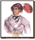 Upon returning home, the Cherokee delegation found themselves threatened by the whole of the tribe. The National Council pronounced them guilty of fraud and deception and declared the treaty null and void. The tribe proposed to send another delegation to Washington since the treaty had been made without authority but the US ignored the request having already ratified the treaty. A large number of Cherokee refused to move to the Indian Territory and elected to join Duwali in Texas which was under Mexican jurisdiction. Among those moving to Texas was the noted chief Tahchee, or Dutch, who had been one of the earliest emmigrants to Arkansas. Tahchee continued to raid Osage settlements in the area of Cantonment Gibson from his home along the Red River. After several years in Texas, he moved to the Indian Territory where he continued raids against the Osage.
In 1833, Cherokees and Creeks met at Cantonment Gibson to settle boundary disputes and precisely establish the boundaries of the new territory. Creeks who had be removed from the east in 1826-27 had found themselves living within the newly established Cherokee lands and were required to move again. The treaty fixed the boundaries for what would become the Cherokee Nation of Indian Territory when the tribe was reunited after the Trail of Tears in 1839. The Arkansas Cherokee, later called the Old Settlers would enjoy only a few years of peace before being joined by the Treaty Party and ultimately by the Eastern Cherokee, marking the beginning of the Cherokee Civil War.